
Apollo 9 Flown Photo Map Checklist Pages - 5-537
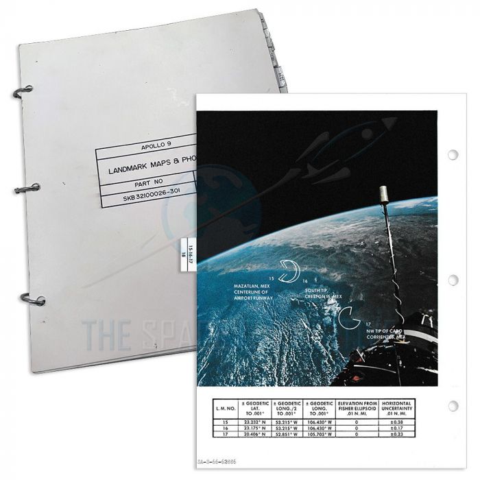
Selection of available double-sided photo pages flown aboard Apollo 9, originally part of the Apollo 9 Landmark Maps & Photos checklist from the collection of Commander Jim McDivitt.
Out of stock
DESCRIPTION
The available double-sided photo map pages came directly from the Apollo 9 Landmark Maps & Photos checklist and originated from the collection of Mission Commander Jim McDivitt. The photos are notated as landmarks and North compass points. All have various NASA photo numbers signifying that they were taken on various Gemini flights between 1965 and 1966. Each has a chart printed beneath giving latitude, longitude, elevation, and horizontal uncertainty calculations for each identified location.
The map plates were intended for an emergency procedure in which the Apollo astronauts could update the spacecraft guidance and navigation computers by inputting precise position information of preselected Earth landmarks. Such maps of candidate landmarks and related data charts were prepared and carried by astronauts in both the Gemini and Apollo programs.
Available Map Plates:
- • Map 8-9/8-10 - Parker Dam, California-Arizona & Santa Eugenia, Mexico - Gemini spacecraft is visible on the lower left of both plates
- • Map 8-9-10-11-12-13/12 - Yayahmko & Cabo Haro Guaymas, Mexico
- • Map 12-13-14/13-14 - Tocsa & Mogote, Mexico - Gemini spacecraft is visible in the middle of one plate
- • Map 20-21 - Biggs Airforce Base & Galveston, Texas
- • Map 23-27 - Corpus Christi, Texas & Carmen Island, Mexico - Gemini spacecraft is visible in the top left of one plate
Product Information:
- • Apollo 9 flown map page
- • Map page measures 10.5" x 8"
- • Includes a certificate of authenticity from The Space Collective
- • Includes a copy of McDivitt's original certificate of authenticity
- • Includes a photograph of McDivitt holding the checklist
- • Optional: Includes an acrylic frame held together with magnets
Authentication Information: These pages were taken from the Apollo 9 landmark maps & photos checklist and came from the collection of Apollo 9 Commander Jim McDivitt. Includes a copy of the original certificate of authenticity and a photograph of McDivitt with the checklist.
Lifetime Guarantee of Authenticity: All of our artifacts are thoroughly and extensively researched before being listed for sale. We're proud to offer a lifetime guarantee of authenticity for this and other artifacts listed on our website. We also hold a record of every piece we sell, which can be identified and searched in our online database using the serial number listed on your certificate of authenticity.
Sold Plates:
- • Map 5-6/7 - Single-Sided - Santa Catalina Island, California
- • Map 15-16-17/18 - Punta Mogote & Mazatlan, Mexico - Gemini spacecraft is visible in the lower right of one plate
- • Map 263/264 - Tuti Island, Sudan & Daga Island, Ethiopia
Description
The available double-sided photo map pages came directly from the Apollo 9 Landmark Maps & Photos checklist and originated from the collection of Mission Commander Jim McDivitt. The photos are notated as landmarks and North compass points. All have various NASA photo numbers signifying that they were taken on various Gemini flights between 1965 and 1966. Each has a chart printed beneath giving latitude, longitude, elevation, and horizontal uncertainty calculations for each identified location.
The map plates were intended for an emergency procedure in which the Apollo astronauts could update the spacecraft guidance and navigation computers by inputting precise position information of preselected Earth landmarks. Such maps of candidate landmarks and related data charts were prepared and carried by astronauts in both the Gemini and Apollo programs.
Available Map Plates:
- • Map 8-9/8-10 - Parker Dam, California-Arizona & Santa Eugenia, Mexico - Gemini spacecraft is visible on the lower left of both plates
- • Map 8-9-10-11-12-13/12 - Yayahmko & Cabo Haro Guaymas, Mexico
- • Map 12-13-14/13-14 - Tocsa & Mogote, Mexico - Gemini spacecraft is visible in the middle of one plate
- • Map 20-21 - Biggs Airforce Base & Galveston, Texas
- • Map 23-27 - Corpus Christi, Texas & Carmen Island, Mexico - Gemini spacecraft is visible in the top left of one plate
Product Information:
- • Apollo 9 flown map page
- • Map page measures 10.5" x 8"
- • Includes a certificate of authenticity from The Space Collective
- • Includes a copy of McDivitt's original certificate of authenticity
- • Includes a photograph of McDivitt holding the checklist
- • Optional: Includes an acrylic frame held together with magnets
Authentication Information: These pages were taken from the Apollo 9 landmark maps & photos checklist and came from the collection of Apollo 9 Commander Jim McDivitt. Includes a copy of the original certificate of authenticity and a photograph of McDivitt with the checklist.
Lifetime Guarantee of Authenticity: All of our artifacts are thoroughly and extensively researched before being listed for sale. We're proud to offer a lifetime guarantee of authenticity for this and other artifacts listed on our website. We also hold a record of every piece we sell, which can be identified and searched in our online database using the serial number listed on your certificate of authenticity.
Sold Plates:
- • Map 5-6/7 - Single-Sided - Santa Catalina Island, California
- • Map 15-16-17/18 - Punta Mogote & Mazatlan, Mexico - Gemini spacecraft is visible in the lower right of one plate
- • Map 263/264 - Tuti Island, Sudan & Daga Island, Ethiopia
